Chasewater Railway
Situated in Chasewater Country Park, the Chasewater Heritage Railway operates a regular passenger leisure service, using vintage steam and diesel locomotives. Founded in 1959, and registered as a charity in 1985, the two mile long, standard gauge track, running between the M6 Toll Rd, and Chasetown Rugby club, is a refurbished section, of the old Midland Railway. Called the Colliery line, due to its involvement in mining logistics, the railway was at the centre of the distribution system, for the numerous collieries in the Norton Canes, and Cannock Chase Coalfields.
A full and comprehensive account of the Chasewater Railway and the well stocked museum, can be found on chasewaterstuffs blog at chasewaterstuff.wordpress.com This covers the full history of the railway from its beginning in 1959 to the present day, and is updated on a very regular basis.
Chasewaterstuffs blog can be accessed directly via the link in my Blogroll which can be found on the right hand side of this page
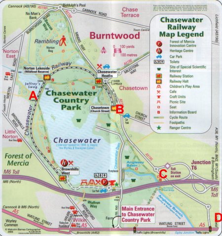
Plan of the track network when it was fully operational

As well as having connections to all the local coal mines, the Midland line was directly linked to the main line at Aldridge, via Brownhills, with a link to Walsall Wood Colliery. There were two other outgoing links, from the Chasewater section of the railway. A semi circular loop to the west, connected with the line to Norton Junction, and a similar curve to the east, skirted the lake, and after passing through Anglesey canal wharf, terminated at Anglesey sidings, which were situated on the Walsall to Lichfield line, at Newtown bridge.

Chasewater Railway track plan as of today. Position A on the map, just before Jeffrey’s swag, was the point where the loop began towards Norton Junction. At position B on the map, Church St station is where the line would have carried on to the canal wharf at point C, then terminating at Anglesey sidings, at position D.
The main station and headquarters of the railway is Brownhills West which is accessible inside Chasewater Country Park.
This is now the end of the line at Brownhills West having been severed by the M6 Toll road
The station area at Brownhills West is totally enclosed with a steel security fence, with large heavy steel track access gates, immediately past the signal box in the picture. The track just to the left of the platform is the start of the 2 mile length of line to Chasewater Church street.
Immediately past the compound gates, is a vehicle crossing from Brownhills Road, Norton Canes, into Chasewater Country Park.
On leaving the station compound, the first landmark is known as Willow Vale Bridge. Originally there was a bridge under the railway, giving access to Chasewater, from Brownhills Road Norton Canes.
The bridge opening was filled in, but the white-painted parapet safety rail can still be seen, standing as a witness to where the bridge stood.
The track takes a downhill gradient, from this point as it passes the public footpath serving the area around Red Lion Lane.
After this crossing, the line then changes to an uphill gradient, as it climbs towards the Causeway. As the line reaches the beginning of the Causeway, there is a pedestrian crossing, heading towards Norton East Road.
This is also where in operational days, a junction formed a line to connect with Norton Junction Marshalling Yard. The track bed still exists to the left of the photo, away from the pool.
The Causeway separates the main pool, from the smaller pool known as Jeffrey’s Swag.
The two pools are connected with a brick-built culvert, under the Railway track.
Immediately past the Causeway is Norton Lakeside Station.
Opposite the platform, is an old track bed from a colliery tramway.
Leaving Norton Lakeside, a right hand sweeping curve, on a slight gradient, takes the track through Windy Woods.
Still negotiating the right hand curve, the track reaches Chasewater Heaths Station, secured with two large track gates, and a steel perimeter fence.
On the exit from Chasewater Heaths Station, is a level crossing, giving vehicle access to the park.
A short distance from the Heaths, is a pedestrian crossing into the Rugby Club.
A few yards further on is Church Street Station.
This is the current end of the line, with a run round loop, allowing locomotives, to change ends on the carriages.
In the days when the line was fully operational, it linked all the local collieries with the National railway and Canal networks. The line would then have circled Norton Pool, as the lake was then called, and terminated at Anglesey Sidings marshalling yard. These sidings where situated on the Walsall to Lichfield line, of the LNWR railway. Sections of the track bed still exist, although extremely overgrown, being slowly re-claimed by Mother Nature.
Passing very close to the Wyrley and Essington canal, enabled coal to be transferred to narrow boats for distribution via the inland waterways. Standing on the edge of the canal at Anglesey Wharf are the remains of the large chutes, where coal was loaded into the waiting narrow boats.
At this point, at Anglesey Wharf, the track bed as been severed by the M6 Toll Road.
An earlier photo taken in 1966, shows the railway crossing over Wharf Lane, now replaced with the new Toll Road motorway.
A typical coal train is seen arriving at Anglesey Marshalling Yard, with a consignment of coal from Chasewater for onward distribution.
A loaded train pulled by No 3, which is a 0-6-0 saddle tank colliery locomotive, is seen making its way East of Chasewater, heading for Anglesey marshalling yard in 1959.
Today Anglesey Sidings Marshalling Yard, is used as a base for a road haulage company specialising in container transport.


October 29, 2009 at 5:41 pm |
hey its laurence. nice blog:) very well done